
GMF Town Hiking Information
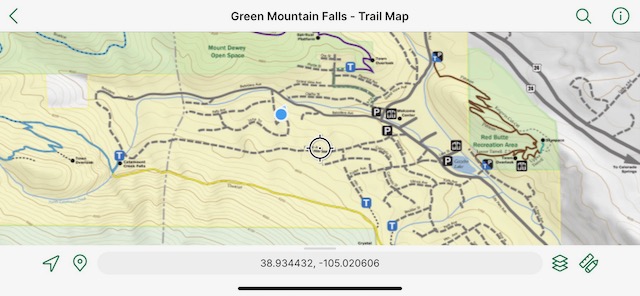
Green Mountain Falls maintains a public trails system consisting of 20 miles of magnificent, pedestrian trails used year-round by locals and numerous visitors. These trails provide access to thousands of acres of national forest land, two scenic waterfalls and three large fishing reservoirs on the nearby North Slope of Pikes Peak.
The Town of Green Mountain Falls in partnership with Ute Pass Elementary, Friends of the Ute Pass Trails and the Historic Green Mountain Falls Foundation have registered this site with the Leave No Trace program. This nationally acclaimed stewardship program encourages the conservation of nature and protection of wildlife and open spaces. Please do your part and follow the Hiker Five and posted regulations in our parks, trails and open spaces to minimize our impact.
Watch for additional signage along the way and enjoy your time in Green Mountain Falls.
Catamount Reservoir Closure Details & QR Code
For an interactive app-based experience, download the Hiking Map and App before arriving. Limited availability of cellular and Wifi in town limits.
For a low-tech experience, download Hiking Map (PDF)
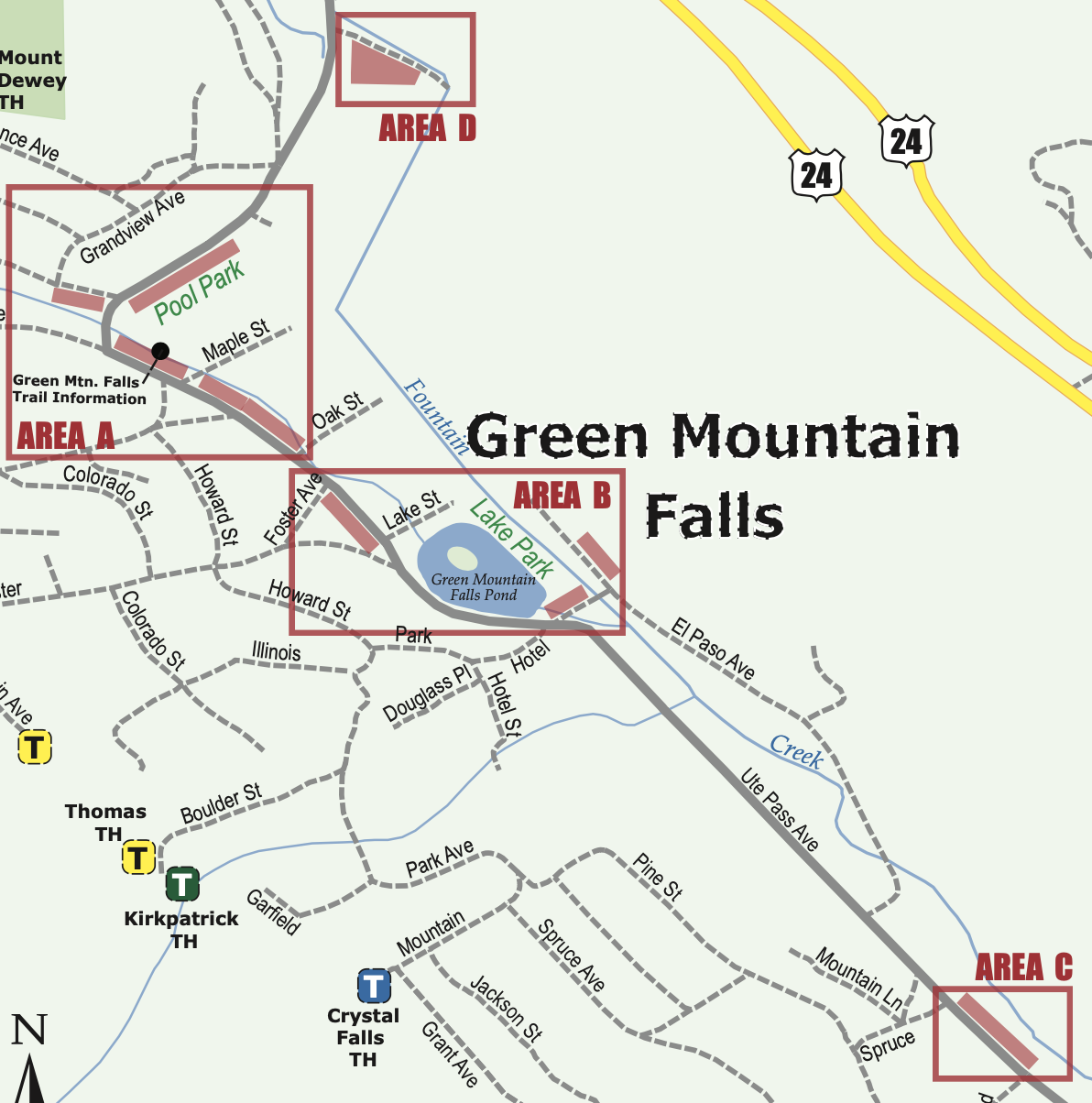
Hiker Parking Areas
AREA A Parking spaces on the northern side of Ute Pass Ave. from Oak St. to the bridge and the southern side of Olathe at Ute Pass Ave. Also at the Pool Park along Ute Pass Ave.
AREA B Parking spaces on the southwest side of Ute Pass Ave. between Lake St. and Foster Ave. Also on Hotel St. between Ute Pass Ave. and El Paso Ave. and on the northeast side of El Paso Ave, just east of Hotel St.
AREA C Ute Pass Ave. at Mountain Rd.
AREA D Ute Pass Ave. and Joyland Church
Bikes are not allowed on any trails except the American Discovery Trail.
Bathrooms are available in town at Gazebo Park and Pool Park.
The Hiker Five

Be Respectful
Stay on the designated trails.
Pack out and dispose of trash and dog waste.
Keep dogs on a leash.
Be Prepared
Pack water and sunscreen.
Plan your route using an official trail map.
Wear layers and proper shoes for hiking.
Be Informed
Be knowledgeable of trail difficulty and conditions.
Check the weather forecast.
Be Courteous
Share the trail.
Keep residential roads passable for vehicles.
Leave what you find.
Be Appreciative
Participate in the quiet of the woods.
Observe wildlife from afar.

About Leave No Trace
Using the power of science, education for all, and stewardship to support and protect nature, Leave No Trace is on a mission to ensure a sustainable future for the outdoors and the planet. Learn more at: www.LNT.org
All measurements approximate (*Distances from the Welcome Center)
|
Trail Name |
Round Trip Distance |
Trail Notes |
|---|---|---|
|
American Discovery Trail ADT Logo |
1.25 miles - one way 186’ |
Easy |
|
Bratton |
1.7 miles - one way 500’ |
Moderate |
|
Catamount - “The Gem of GMF trails” |
Catamount Falls: 2 miles* Garden of Eden: 4 miles* Reservoirs: 6.3 miles* 1600’ |
Moderate |
|
Conn |
.2 miles* Flat |
Easy walk along the creek Art walk, shopping, food |
|
Crystal |
3.6 miles* 1700’ |
Difficult |
|
Dewey (Top) |
2.3 miles* 720’ |
Moderate |
|
Dewey/Bratton/Catamount |
4.2 miles* 1450’ |
Moderate |
|
Kirkpatrick |
1.6 miles - one way* 240’ |
Moderate |
|
Pittman/Turrell Trails |
1.25 miles 300’ |
Easy |
|
Thomas |
2.6 miles* 360’ |
Moderate |
|
Wallace Reserve |
2.0 miles Various |
Easy |